Strengthen our foundations
Improve water systems, coordinate infrastructure, and make development easier to navigate.
Explore the first steps →OUR RESOURCES. OUR PEOPLE. OUR FUTURE.
From the shores of Toledo Bend to the heart of our hometowns, explore a shared vision for Sabine Parish’s next chapter.
An interactive companion to the 2026 Comprehensive Plan
 ROOTED IN SABINE. LOOKING AHEAD.
01 / THE BIG PICTURE
The plan connects what makes Sabine special—water, woodlands, culture, and community—with the infrastructure and opportunities needed for a resilient future. Executive summary · p. 6 ↗
Improve water systems, coordinate infrastructure, and make development easier to navigate.
Explore the first steps →Use three signature corridors to link hometowns, lake destinations, industry, and everyday services.
Follow the corridors →Build leadership, workforce pathways, and partnerships that turn local strengths into lasting opportunity.
Meet the implementation partners →Align efforts · Model stewardship · Celebrate unique culture & history · Connect for success · Destination hometown · Meet in the middle
p. 13 ↗02 / A PLAN FOR YOUR PLACE
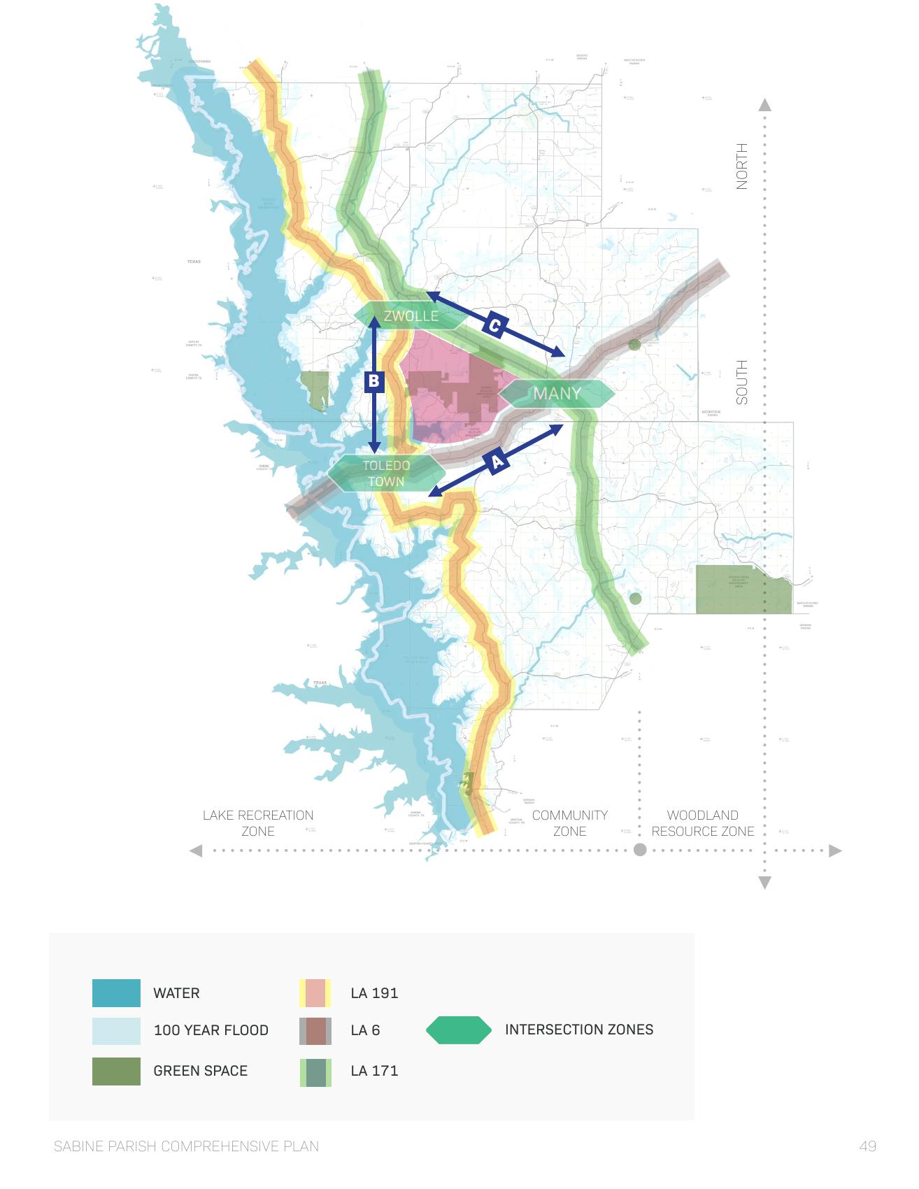
Choose a community or corridor to see what the plan proposes there. The original framework map shows how the pieces fit together.
03 / FROM VISION TO ACTION
The plan identifies ten high-priority implementation initiatives. Filter by the role each plays, then open a priority to see the idea in plain language. Implementation strategy · p. 92 ↗
Leadership development, one-stop permitting, workforce development, conservation buffers, a community foundation, population metrics, water infrastructure, and DOTD engagement.
Read the eight initiatives, explained ↓04 / UNDERSTAND THE CONTEXT
A few indicators that help explain the plan’s priorities. Figures below are reported in the PDF and reflect its historical data, rather than current measurements.
The report describes a population stabilizing near 22,000, with an aging population and a need to attract younger residents.
Demographics · p. 19 ↗A strong base of homeowners. The plan also highlights the need for affordable entry points for younger families.
Housing · p. 26 ↗The plan calls for consolidation and infrastructure upgrades to improve consistency of service.
Water infrastructure · p. 37 ↗TRY A PLANNING SCENARIO
Seasonal visitors change service demand. Slide from the approximate resident baseline to the plan’s potential 3× lake-influenced population scenario.
Population metrics · p. 36 ↗Illustrative only: 22,000 × selected multiplier. Not a measured visitor count or forecast.
05 / SHARED RESPONSIBILITY
The Economic Development Committee is proposed as the implementation lead. The Chamber’s assignments include coordinating implementation under the EDC, tracking performance, pursuing funding, and rebuilding leadership development.
Police Jury, planning bodies, municipalities, schools, DOTD, and other state partners help coordinate land use, regulation, infrastructure, and education.
Assignments · pp. 94–96 ↗Utilities, water districts, and the railroad coordinate systems, share mapping data, and prepare for future development. The plan sets a water-system reduction goal of 50% before 2030.
Assignments · p. 97 ↗The Chamber, medical providers, financial institutions, and festival organizers support leadership, health, community investment, and recreation.
Assignments · p. 98 ↗A proposed Sabine Community Foundation and BPCC/NSU partnerships would connect philanthropic investment, redevelopment, workforce education, and entrepreneurship.
Innovation · p. 99 ↗06 / READ & UNDERSTAND THE PLAN
Read the plan in plain language, right here. Explore 44 digested topics covering its findings, early initiatives, corridors, community proposals, and implementation responsibilities. Page references let you check the original without interrupting the story.
44 topics · Full explanations below
Introduction / 01
Preserve the character of Sabine Parish while making growth more coordinated, practical, and resilient.
The plan starts with two powerful assets: Toledo Bend on the western side of the parish and forestry, agriculture, and energy resources in the eastern woodlands. Between them are the towns, schools, businesses, and services that make daily life possible. The central idea is to connect these assets through existing corridors and concentrate investment where communities and infrastructure can support it.
The result is a framework for decisions about land use, public services, transportation, economic development, and community life. It pairs immediate organizational and infrastructure work with longer-term place-specific projects. It does not mean every illustrated development is funded or scheduled.
Process / 02
Local stakeholders worked with planners to turn shared aspirations into a parish-wide framework.
Community leaders engaged Tipton Associates and Ashe Broussard Weinzettle in fall 2024. A steering committee began meeting monthly in January 2025. Across seven working sessions, stakeholders reviewed infrastructure, demographics, resources, challenges, and potential responses.
The resulting six principles are a test for future decisions: align efforts, model stewardship, celebrate unique culture and history, connect for success, create a destination hometown, and meet in the middle. In practice, the plan asks partners to work across boundaries while balancing community needs, environmental resources, and economic opportunity.
Analysis / 03
An aging population, strong homeownership, and changing school enrollment shape the plan’s focus on people.
The report describes a population stabilizing near 22,000 and a median age of about 40. It reports that the share of residents aged 65 and older increased from 17.3% to 21.4% by 2022. The planning implication is to support older residents while improving the jobs, housing, education, and recreation that can attract and retain younger households.
Housing is a strength, but access matters. The report gives an 80.3% homeownership rate and 14,020 housing units as of July 2024. It describes many unoccupied units as seasonal camps or vacation homes, so an empty unit does not necessarily represent housing available to a new permanent resident. The plan calls for affordable entry points and neighborhood investment alongside protection of established communities.
Analysis / 04
A resident count alone does not capture demand around Toledo Bend.
Visitor analytics in the report cover January through August 2025 and show spikes around bass tournaments and summer holidays. The report identifies Lafayette, Lake Charles, and Baton Rouge among leading visitor origins, with growth from New Orleans and Shreveport.
That pattern creates a practical planning challenge: water, utilities, roads, and other services must work during busy periods as well as ordinary weekdays. The plan recommends combining visitor information with vacation-rental and utility data to understand the population actually using parish services. Its potential three-times population scenario is a planning consideration, not a measured count for every weekend.
Analysis / 05
The report connects growth with workforce participation, income gaps, and poverty.
The report records median household income of $53,183 in 2023 and an individual median income of about $26,888. It also reports a 19.3% poverty rate and a labor-force participation rate of 46.6% for people over 16. These historical indicators explain why the plan emphasizes access to training and work as well as business recruitment.
Income differences across demographic groups and between men and women remain part of the picture described in the plan. Its response is to broaden opportunity through education, workforce partnerships, entrepreneurship, and coordinated economic development. The site presents these numbers as report-era context rather than a live economic dashboard.
Source pages: p. 22 ↗ · p. 23 ↗ · p. 24 ↗ · p. 25 ↗ · p. 35 ↗ · p. 98 ↗
Analysis / 06
Strong K–12 results sit alongside falling enrollment and a need for education beyond high school.
The report gives a school district performance score of 88.6 in 2025 and enrollment of 3,947, down 11% since 2018. It also reports that 85.7% of adults hold a high school diploma and 14.5% hold a bachelor’s degree. Together, these findings support both attracting younger families and expanding routes into technical and higher education.
The plan proposes stronger relationships among parish schools, Bossier Parish Community College, Northwestern State University, and employers. Distance learning, dual enrollment, internships, apprenticeships, and job placement can connect education to local work. The report’s text and chart give different statewide bachelor’s-degree comparison figures; the local figure is used here without presenting a single statewide comparison as settled.
Source pages: p. 28 ↗ · p. 35 ↗ · p. 77 ↗ · p. 95 ↗ · p. 99 ↗
Analysis / 07
Existing industries provide the base for research, new products, and transportation investment.
The report identifies forestry and forest products as major economic anchors. For 2021, it reports $346.5 million in output, 1,297 supported jobs, and $80.8 million in labor income. Agriculture adds diversity through poultry, livestock, and other production. These are historical figures cited in the plan.
Natural gas is another major resource, with infrastructure and high-wage work that influence land-use choices. The plan argues that industrial transport, residential growth, and recreation must be planned together. It explores new forestry products, research, and energy markets as opportunities to investigate, rather than established projects already operating.
Source pages: p. 30 ↗ · p. 31 ↗ · p. 32 ↗ · p. 52 ↗ · p. 53 ↗ · p. 54 ↗ · p. 55 ↗ · p. 63 ↗
Analysis / 08
The plan treats the parish’s borderland heritage and historic places as assets to connect and interpret.
The historical chapter traces indigenous travel and trade, El Camino Real, changing territorial boundaries, and the development of Toledo Bend. These stories help explain why the east–west corridor, railway communities, and the lake remain central to the parish’s identity.
The development recommendations carry that history into gateways, wayfinding, cultural content, and reuse of historic buildings. Examples include an interpretive role for Many’s historic post office, train depots as community landmarks, and gateway designs in Zwolle that recognize indigenous heritage and the confluence of cultures.
Source pages: p. 15 ↗ · p. 16 ↗ · p. 17 ↗ · p. 61 ↗ · p. 73 ↗ · p. 85 ↗ · p. 86 ↗ · p. 96 ↗
Immediate initiatives / 09
Rebuild a network that prepares younger professionals to help guide parish progress.
A leadership development program combines networking and education with exposure to real community challenges. The plan describes benefits such as retaining talent, sharing knowledge across generations, and using capstone projects to work on practical problems.
The Chamber is assigned to re-establish this program. Its value is not simply a series of meetings: it creates relationships and an engaged pool of people who can work across public, private, and service organizations.
Immediate initiatives / 10
Put development requirements in a place people can understand and use.
The plan proposes an up-to-date website that streamlines the permitting experience for entrepreneurs and government employees. A clearer process can reduce time spent finding requirements and navigating separate offices.
The Planning Commission’s related assignments include publishing requirements and project status, updating codes and property standards, and reviewing subdivision standards. Streamlining is paired with clearer rules; it does not imply eliminating review.
Immediate initiatives / 11
Link skills, employers, and education instead of treating them as separate systems.
The proposed workforce program brings employers and educational institutions together around in-demand jobs. It includes skills training, apprenticeships, career counseling, and job placement.
The implementation assignments for schools and BPCC/NSU extend that idea through dual enrollment, distance learning, internships, and partnerships with industrial and private employers. The intended result is a clearer route from school or retraining into work.
Immediate initiatives / 12
Small areas of permanent vegetation can support water, soil, and wildlife.
The plan describes filter strips, riparian corridors, grass waterways, and field borders as tools for conservation. These buffers protect natural functions while seeking to limit disruption to agricultural production.
This connects to the wider emphasis on lakefront stewardship, scenic-corridor protection, and landscape separation between industrial and community uses. Appropriate buffers vary with the setting; the report does not give a single site-wide prescription for every property.
Immediate initiatives / 13
Create a lasting vehicle for local philanthropy and investment in community needs.
A proposed Sabine Community Foundation would pool private resources through endowments and targeted grantmaking. The plan presents it as a permanent funding engine for nonprofits and longer-term civic projects.
The innovation chapter gives it a broader potential role: acquiring and assembling land, returning adjudicated properties to commerce, supporting redevelopment for the public good, and investing in enterprises that support employment. These are proposed capabilities, not a statement that such an entity or investment program is already in operation.
Immediate initiatives / 14
Improve population benchmarks before making growth decisions.
Permanent population, vacation homes, short-term rentals, and visitors create different patterns of service demand. The plan recommends tools such as vacation-rental information and utility consumption to account for the lake-influenced population.
The Police Jury and Tourist Commission are assigned to cooperate on determining, tracking, and publishing accurate parish population data. Better benchmarks support proactive economic development and infrastructure planning.
Immediate initiatives / 15
Address uneven system performance and aging infrastructure.
The report identifies 17 independent water systems with an average score of 71.8 and grades ranging from A to F. It prioritizes consolidating failing systems and upgrading distribution infrastructure.
Water districts are assigned to reduce the number of separate systems by 50% before 2030, pursue grant funding for upgrades, plan for future demand, and share system maps for parish GIS integration. The percentage and deadline are goals in the plan, not a verified progress report.
Immediate initiatives / 16
Treat transportation as a partnership and a long-term investment.
Timber, gas, and other industries depend on viable transportation corridors. The plan calls for bridge replacements, safety overlays, and advocacy in state funding cycles.
DOTD assignments also include cooperation on the LA 6/LA 191 intersection, access to historic and development sites along LA 6, scenic-byway standards for LA 191, and Lee Jordan Road improvements. These connections serve industrial logistics, visitors, and community development together.
Framework plan / 17
Focus growth where lake life, community services, and woodland resources meet.
The western Lake Recreation Zone includes waterfront homes, camps, resorts, and public and private recreation. The middle Community Zone contains most towns, schools, retail, and services. The eastern Agriculture & Resource Zone is less densely populated and includes forestry and energy resources.
LA 191 follows the lake, US 171 connects the industrial and community spine, and LA 6 crosses between Texas, Toledo Town, Many, and the eastern region. The framework uses those connections to link complementary uses rather than plan each place in isolation.
Water and flood-prone areas constrain where continuous development is possible. The plan favors a clustered approach near existing corridors and services while protecting natural buffers. The land-area figures are presented in the original analysis; this digest does not reconstruct a parcel-level buildability calculation from those percentages.
Source pages: p. 39 ↗ · p. 40 ↗ · p. 41 ↗ · p. 42 ↗ · p. 44 ↗ · p. 46 ↗
Framework plan / 18
The plan’s three conceptual zones organize different kinds of investment.
The Hospitality and Service Zone is aimed at residents and the regional drive market: groceries, pharmacies, personal services, hotels, restaurants, and cultural attractions. The Entertainment and Recreation Zone focuses on leisure needs, outfitters, guides, outdoor activities, and indoor entertainment.
The Research and Enterprise Zone supports existing and emerging forestry and energy interests, including manufacturing, biofuels, research facilities, and multimodal transportation. These are framework land-use concepts. They should not be confused with a confirmed federal tax-zone designation or an already-approved project.
Corridor priorities / 19
El Camino Real can connect heritage, tourism, and everyday community services.
The high-priority recommendations include regional promotion partnerships, technology-enabled communication, a public overlook and recreation at the state line, and a regional lifestyle center near LA 6 and LA 476. The report envisions the Pendleton Bridge area as a prominent welcome destination with lake views, recreational access, retail, and events.
The corridor also needs landscape buffers, clear gateway markers, and careful development at strategic segments. Near Fort Jesup, the plan identifies potential residential development that builds on the historic setting. A lifestyle center is a proposed concentration of retail, lodging, restaurants, and services; it is not an announced development.
Source pages: p. 59 ↗ · p. 60 ↗ · p. 61 ↗ · p. 67 ↗ · p. 69 ↗
Corridor priorities / 20
The Toledo Bend Forest Scenic Byway should support lake communities without losing its scenic character.
The plan prioritizes mid-lake community-scale development, stronger north and south gateways, an expanded scenic experience from Zwolle to Negreet, and strategic development at south-lake intersections. Concentrating amenities and using forest-management buffers are ways to keep development compatible with the landscape.
Recreation recommendations include improvements at Converse Bay, lake overlooks and access around San Patricio, and mid-lake experiences near Cypress Bend. Proposed water-route connections could link resorts, parks, and existing docks. They are opportunities for future coordination, not operating transit services.
Source pages: p. 59 ↗ · p. 64 ↗ · p. 65 ↗ · p. 66 ↗ · p. 67 ↗
Corridor priorities / 21
The Purple Heart Highway is central to the parish’s forestry and enterprise strategy.
The plan identifies forest-commerce opportunities around Noble, between Zwolle and Many, and near the Many–Fisher area. Its site considerations include consolidated ownership, rail and highway access, proximity to workforce centers, and locations outside the 100-year floodplain.
The broader corridor strategy also reinforces community identity and historic amenities. Connectors toward LA 191, LA 474 access to Toledo Bend, and Lee Jordan Road connectivity help link industrial and residential areas with the lake. The Hart Airport connection is a key example of aligning highway, rail, and air access.
Source pages: p. 59 ↗ · p. 62 ↗ · p. 63 ↗ · p. 69 ↗ · p. 78 ↗
Corridor priorities / 22
Research and fabrication could extend the benefits of an established forestry economy.
The plan identifies the Louisiana Ecological Forestry Center at the former Hodges Gardens site as a research and education asset. Its proposal is to connect the center with regional or national research, industry, and workforce relationships. The report describes LEAF as a research destination rather than a public park.
Mass timber, including cross-laminated timber, is discussed as a potential manufacturing opportunity. Biochar, biomass fuels, bioplastics, and cellulose nanomaterials offer possible uses for forestry and agricultural byproducts. These ideas could create work in production, manufacturing, and logistics, but the plan first calls for a specialist forest-industry market analysis to guide recruitment.
Source pages: p. 52 ↗ · p. 53 ↗ · p. 54 ↗ · p. 63 ↗ · p. 92 ↗
Corridor priorities / 23
The report considers energy diversification and the community concerns that come with it.
The energy chapter discusses solar, pairing solar with agriculture or habitat, carbon capture and storage, and hydrogen-related opportunities. It sees existing resource and pipeline infrastructure as a potential economic advantage.
It also records concerns about storage integrity, aquifers, monitoring transparency, and pore-space rights in relation to carbon storage. The report calls for clear local ordinances and safety protocols. These are proposals and considerations from the report; the site does not assert that a particular project is safe, approved, or eligible for a current incentive.
Source pages: p. 55 ↗
Corridor priorities / 24
Link outdoor experiences to town centers and local businesses.
The plan argues for more than seasonal lake visitation. Trails, pedestrian connections, outdoor experiences, and support businesses can help translate natural assets into benefits for communities throughout the year.
Examples include outfitters, equipment retail, guide services, lodging, food, and recreation events. Hospitality proposals range from retreats and vacation-rental communities to eco-tourism and corporate gatherings. The report recommends a shared regional marketing umbrella while retaining individual neighborhood and community identities.
Corridor priorities / 25
The framework extends beyond the three primary community focus areas.
Converse and Converse Bay combine a north-corridor crossroads with park and eco-tourism opportunities. Noble’s undeveloped parcels could support a clearer community core, mixed uses, identity, and civic space. Fort Jesup offers a heritage anchor and a possible setting for residential development.
Carter’s Ferry and the LA 1215 loop could benefit from community resources at intersections, greenways, and water connections. Fisher’s historic company-town street pattern is an asset to preserve while extending connections. Florien’s LA 474 and Lee Jordan Road connections link the south to the lake. In Negreet, the school is identified as a community anchor, with nearby intersections offering retail and residential possibilities.
Community priorities / 26
Make the town center a connected destination for business, culture, and community.
The Downtown Core and Civic Square proposals combine gateways at LA 6/US 171 and LA 6/Church Street with mixed-use infill that can restore the two-story downtown street pattern. The plan also calls for highlighting the Capitol/LA 6 intersection.
A central change is to consolidate parking in designated locations and return courthouse grounds to civic space. The existing library remains a downtown asset. Better sidewalks and landscaping would connect parking, businesses, and public uses. The historic post office is proposed as a regional or national El Camino Real interpretive center, with cultural and funding partners helping explore reuse.
Community priorities / 27
Use existing streets, parcels, and cultural landmarks to repair gaps in the town fabric.
At Capitol and US 171, the plan proposes gateway improvements and a stronger connection to the train depot as a landmark and cultural attraction. A crossroads pocket park would recognize the former US 171 route.
Neighborhood recommendations include activating the Mississippi Avenue median, using MLK as a north–south connector to LA 6, and returning 24 parcels described as under parish control to residential use. The emphasis is on reconnecting established neighborhoods rather than allowing isolated parcels to remain disconnected.
Source pages: p. 74 ↗
Community priorities / 28
Extend the value of existing recreation assets with trails, fields, and greenways.
The Recreation District recommendations start with walking and biking trails around the fairgrounds and possible extensions if additional property is acquired. A modified ring road could support four regulation soccer fields or sixteen youth fields. These layouts are possibilities shown in the plan, not construction announcements.
Parish-road upgrades would establish greenway connections toward Fisher and Negreet. Adjacent land and local terrain could support expansion of the recreation complex and a distinctive trail network. The report also proposes partnering with Natchitoches Parish on economic use of existing assets.
Source pages: p. 75 ↗
Community priorities / 29
Coordinate hospital access, related services, land use, and public amenities.
The plan proposes a city/regional health district and an economic development zone to encourage compatible investment. Planning and zoning updates would support ancillary health and wellness uses.
Recommendations include reorienting the hospital entrance for better visibility and access, integrating the Council on Aging property into the district, and exploring a stormwater detention area as a wellness asset and visual landmark along US 171. Implementation assignments ask medical partners to align their master plan and consider land acquisition or swaps where they improve accessibility.
Community priorities / 30
Connect the school campus, learning opportunities, and nearby residential life.
The Educational Village proposal would integrate distance-learning capacity into the school campus and work with BPCC and NSU to extend its use beyond regular school hours. A wireless hotspot is proposed to support community engagement.
The residential side of the idea is an academic village: planned housing options near the educational anchor, with consideration of city-limit expansion to include existing and new development. Education and housing would be considered together rather than as unrelated investments.
Source pages: p. 77 ↗
Community priorities / 31
Bring road, rail, and airport access into one coordinated district strategy.
The report identifies more than 600 acres as potentially accessible in the multimodal area. It proposes connecting Virginia Godfrey Drive to McDonald Drive for US 171 access, opening parcels with highway, railroad, and airport connections. A new connector toward US 171 would also support a strategic southern connection between US 171 and LA 6.
Additional hangar sites could serve tourism and corporate needs, while road updates could improve greenway connections among Many, Fisher, and Negreet. The plan calls for reconsidering industrial zoning and marketing so access improvements and recruitment reinforce each other. Potential acreage is not the same as land confirmed available for a specific development.
Community priorities / 32
Shared infrastructure and business coordination are the foundation of the proposal.
The report observes a largely vehicle-oriented crossroads, with infrastructure addressed parcel by parcel and little pedestrian connection or shared place identity. Its high priorities are an economic development zone, a business association, physical infrastructure, parcel assembly, and basic development standards.
Undeveloped frontage on LA 6 and LA 191 could accommodate a more coherent community pattern. Memory Lane offers an alternate access opportunity, while topography can help define greenways and development areas. Cooperation among businesses, the parish, SRA, DOTD, and utilities is essential because no single parcel owner can create the whole network.
Source pages: p. 71 ↗ · p. 79 ↗ · p. 80 ↗ · p. 94 ↗ · p. 96 ↗ · p. 97 ↗
Community priorities / 33
Early public-space improvements can make separate businesses feel like a community.
The initial community-development proposal adds civic space at strategic locations and landscaped pedestrian connections among existing parcels. Planned safe crossings are a key part of making those links usable.
Signature trees along LA 6 and LA 191, better landscaping, and protected outdoor dining at primary intersections would reinforce identity and improve the experience on foot. These early steps support the larger town-center idea while addressing the existing crossroads.
Community priorities / 34
The longer-term concept combines everyday services, visitor uses, housing, and civic life.
The town-center proposal includes hospitality and specialty retail, extended-stay apartments, boutique loft rentals, single-family homes, townhouses, civic performance space, and outdoor events. A boardwalk character, wireless access, landscaping, and public-safety facilities form part of the concept.
The report suggests an initial phase at the southeast corner of LA 6/LA 191, expandable as demand supports it and potentially on both sides of LA 6. It combines on-street parking with lots inside blocks and uses Memory Lane as a residential-scale entry. The existing lake and terrain are treated as amenities and water-management opportunities. This is a phased land-use concept, not a confirmed building program.
Community priorities / 35
Gateway improvements would link culture, wayfinding, and access to the town center.
At the Front Door and Crossroads District, the plan proposes a prominent marker, landscaping, tree preservation and restoration, and a landform recognizing indigenous mound builders. It builds on existing fire-protection facilities as part of the arrival experience.
At Oak and Obrie Streets, branding, historical information, wayfinding, and sidewalks would connect the crossroads to the core district and mark access to outdoor experiences. The northern gateway proposal similarly combines a marker, landscaping, indigenous recognition, and international flags to express the confluence of cultures.
Community priorities / 36
A continuous greenway would make existing destinations work as a network.
The proposed South Main greenway combines shade trees, multi-use paving, and pedestrian-scale lighting. It connects the festival grounds, train depot, St. Joseph Catholic Church, and routes toward Bayou Scie, while maintaining required railway clearance.
The industrial strategy anticipates future rail-served expansion and uses landscape buffers to separate industrial views from community streets. The Lake Gateway proposals extend greenway and screening connections and include a southern gateway feature with an existing pond retained as a reflecting pool. Recreation, industrial access, and community appearance are addressed together.
Community priorities / 37
Connect event space with everyday recreation and nearby natural systems.
The plan proposes a pedestrian midway sized to accommodate field sports, a more organized vehicle entrance, and designated parking that serves regular use as well as events. Pedestrian paths and a perimeter multi-use greenway would connect the grounds to the wider network.
Access from Port Arthur Street and trail connections east to Bayou Scie expand the site’s role. This supports the broader idea of festivals as anchors for recreational activity and new events, rather than sites used only during a few annual gatherings.
Community priorities / 38
Four proposed outposts would connect the town with trails, bayous, and wildlife-management areas.
The outposts share a basic kit: trailhead parking, pavilions, cultural information, wayfinding, and trail or boardwalk connections. Outpost 1 includes blueway access near the front-door district. Outpost 2 uses parish roads to reach multiple Sabine Wildlife Management Area locations, with primitive camping and potential hiking, biking, and possibly ATV routes.
Outposts 3 and 4 are identified at Clyde’s Crossing and Bayou Scie, with blueway and lake access. Hurricane Creek is identified for water access in the Outpost 2 concept. These are proposed destinations and connections; they should not be read as directions to completed, publicly accessible facilities.
Source pages: p. 85 ↗ · p. 88 ↗ · p. 89 ↗ · p. 90 ↗ · p. 92 ↗
Implementation / 39
The ten priorities form a sequence of responsibilities rather than ten unrelated projects.
The two leadership initiatives establish the EDC as implementation lead and create a Sabine Community Foundation. Four enabling initiatives then build economic-development capacity, improve water coordination, streamline planning review, and establish better population metrics.
The four project initiatives focus on the Pendleton Bridge gateway, infrastructure at LA 6/LA 191, the Hart Airport/US 171 connection, and Zwolle’s adventure outposts. The logic is to create organizations and shared systems that can support capital projects. The report does not provide a funded construction calendar for these ten initiatives.
Implementation / 40
Implementation depends on accountability across organizations.
The report calls for the Economic Development Committee to serve as the primary lead, with representation across key parish constituencies. At least one annual Leadership Summit would report progress and create public accountability. Regional engagement with LED, NLEP, USDA, the Delta Regional Authority, and neighboring partners is part of the strategy.
The Chamber is assigned to lead implementation under the EDC, establish performance metrics, report results regularly, cooperate on an economic-development position and forest-industry study, pursue grants and other funding, re-establish leadership development, and encourage aligned private investment. These are assignments in the plan, not verified statements that each activity is already underway.
Implementation / 41
The Police Jury, municipalities, schools, state agencies, and SRA have complementary assignments.
The Police Jury’s proposed work includes economic-development capacity, opportunity-zone marketing, a future land-use map, updated subdivision and development standards, web-accessible review, and accurate population data. The Planning Commission is asked to update and clarify the regulatory process.
The schools expand education and workforce partnerships. The Tourist Commission broadens marketing and recreation opportunities and helps measure population. SRA assignments include the Pendleton Bridge gateway, cooperation at LA 6/LA 191, overlooks, lake-development conservation guidance, and exploration of water connections with state parks. Municipalities protect neighborhood fabric and concentrate services at key intersections.
Implementation / 42
Utilities, water districts, and the railroad are asked to plan proactively and share information.
Utilities are assigned to improve data infrastructure, consider hotspots at cultural sites, prepare power and data at LA 6 locations, and partner on services at LA 6/LA 191. Sharing system maps and interface points with the parish supports GIS coordination.
Water districts are assigned consolidation, upgrades, grant pursuit, and system mapping. Rail partners are asked to work with economic-development interests on access in designated multimodal areas and support redevelopment of historic stations in communities such as Many, Fisher, and Florien. The common theme is investing in a connected system before growth creates urgent pressure.
Source pages: p. 97 ↗
Implementation / 43
Health, finance, festivals, and learning institutions help turn physical investments into community benefit.
Medical partners are asked to align the Sabine Medical Center master plan with the Health District, improve visibility and access through land strategies, and explore a Toledo Town clinic alongside other investment. Other assignments include financial-institution participation in the community foundation and broader recreation partnerships.
Festival organizers could expand adventure competitions and eco-tourism activities as catalysts for additional events. BPCC and NSU are assigned partnerships around dual enrollment, distance learning, employer training, internships, and job placement. The proposed foundation adds an entrepreneurial and redevelopment partner that can connect public and private resources.
Implementation / 44
The plan identifies funding avenues to investigate, not guaranteed awards.
The report discusses incentive programs, potential federal opportunity-zone designation, state new-markets credits, and LED Certified Sites. It records the designation process as it stood in spring 2026 and notes changes to other programs. Those passages are time-sensitive, so this digest treats them as report-era context rather than current tax or eligibility guidance.
The actionable planning recommendation is to research opportunities, prepare sites and proposals, and coordinate with the relevant partners. The Chamber, EDC, Police Jury, and regional agencies each have roles in connecting parish priorities with grants, certification, and investment. Funding availability and qualification must be confirmed for the actual project and application date.
No matching topics. Try a broader term or choose all chapters.
These editorial summaries explain the supplied 2026 Sabine Parish Comprehensive Plan, prepared by Tipton Associates with Ashe Broussard Weinzettle. Recommendations, concepts, and assignments are attributed to the plan; their inclusion here does not establish current approval, funding, or completion. The original PDF contains detailed maps, charts, qualifications, and source data. Unfinished placeholder text is omitted, and inconsistent source figures are noted where relevant.
Artwork and framework imagery are reproduced from the supplied plan. Visit the Sabine Parish Chamber of Commerce website ↗ for Chamber information.